I read on a site today if you use the new version of Google Earth you can use a Flight Simulator by easily pressing '[ALT] [CTRL] [A]'.
It gives you the option of flying an F16 or a SR-22 a small 4 seater light aircraft. I tried the light aircraft to see if I could fly over the Tranporter Bridge.
I ended up crashing into the Tees. So it is quite a realistic flight sim, for an add-on to a system. I'm gonna have another go tonight with the F16. A low high speed pass.
It is quite a good programme to use considering Microsofts Flight Sim you have to pay shit-loads to get realistic land simulations of areas that you want to fly over.
Update: I tried again with the F16 and failed. Went for a low pass over Roseberry topping and ending up crashing near Yarm.
Showing posts with label google earth. Show all posts
Showing posts with label google earth. Show all posts
Saturday, October 20, 2007
Thursday, December 21, 2006
Friday, December 08, 2006
Lancaster Bomber
Two different satellite photos of the same location, the corner of Lake Way and Hayeswater in Huntingdon, taken around the same time but 1 striking difference.


Spot the difference.
The second one features the Battle of Britain Memorial Flight Avro Lancaster, the City of Lincoln pictured below. It was discovered by a resident of one of the houses in the photo while he was trying to locate his place of residence.

'the City of Lincoln'
The plane was used in the film Guns of Navarone

Guns of Navaron featuring David Niven, Gregory Peck and Anthony Quinn.
The 'Guns' featured Greek actreess Irene Papas who also starred in Captain Corelli's Mandolin and was was once dubbed by Catherine Hepburn as "one of the best actresses in the history of cinema"

Irene Papas
View from Virtual Earth:

View from Google Earth:

Spot the difference.
The second one features the Battle of Britain Memorial Flight Avro Lancaster, the City of Lincoln pictured below. It was discovered by a resident of one of the houses in the photo while he was trying to locate his place of residence.

'the City of Lincoln'
The plane was used in the film Guns of Navarone

Guns of Navaron featuring David Niven, Gregory Peck and Anthony Quinn.
The 'Guns' featured Greek actreess Irene Papas who also starred in Captain Corelli's Mandolin and was was once dubbed by Catherine Hepburn as "one of the best actresses in the history of cinema"

Irene Papas
Thursday, October 26, 2006
Out in the sticks
Yesterday I had probably the hardest breakdown location in 2 years of working when a chummy yorkshireman rang in with a location near darlo. After asking me where I was he was not too convinced I would find him. "Eye up lad they have ney idee". I tried to convince him by telling him I knew the NYork Moors quite well.
Our man in distress had been picking mushrooms. And a generous lady had brought him back to his house leaving the car in the back and beyond. "Oh it t'was vey kind lark, but she shuddna werry coz im arnly an awl baldy gadgy , ney harm."
After the original distress he started to explain where he was. But it wasn't that easy.
He had been living in the area a long time and had only just found this farm track himself. After 10 minutes I thought i had it. I asked him if he would mind meeting the technician up there....
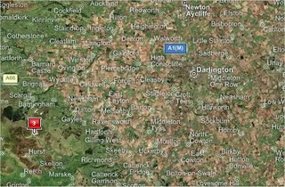
Only 30 minutes from Darlo
"Nee lad we'll make a dahy of it . Aye'll tahk a picnic liykh and we can hav a game of footy"
Very comic for a 70 yr awld gadge. Anyway I was a bit concerned we would find him so I asked the tech to go and pick him up from him house instead. And after arriving at the so called broken down vehicle it turns out that it wasn't broken down at all. He didn't know how to use the manual key in his electronic key fob and it would have started if he had use it.
As he said "It's a nice day for a trip up the moors like". And so it was for both of them.
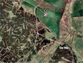
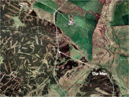
After sending the tech into no-mans land (An Army firing range) I was curious to see this so called 'middle of nowhere'. Live local shows it is a bit barren up there. I don't know what the MOD are doing up ther but the land looks a little strange. Tank tracks maybe?, Not the best place to be picking mushrooms.
Mushrooms are not that expensive at Darligtons Morrisons Supermarket.
Our man in distress had been picking mushrooms. And a generous lady had brought him back to his house leaving the car in the back and beyond. "Oh it t'was vey kind lark, but she shuddna werry coz im arnly an awl baldy gadgy , ney harm."
After the original distress he started to explain where he was. But it wasn't that easy.
He had been living in the area a long time and had only just found this farm track himself. After 10 minutes I thought i had it. I asked him if he would mind meeting the technician up there....

Only 30 minutes from Darlo
"Nee lad we'll make a dahy of it . Aye'll tahk a picnic liykh and we can hav a game of footy"
Very comic for a 70 yr awld gadge. Anyway I was a bit concerned we would find him so I asked the tech to go and pick him up from him house instead. And after arriving at the so called broken down vehicle it turns out that it wasn't broken down at all. He didn't know how to use the manual key in his electronic key fob and it would have started if he had use it.
As he said "It's a nice day for a trip up the moors like". And so it was for both of them.
After sending the tech into no-mans land (An Army firing range) I was curious to see this so called 'middle of nowhere'. Live local shows it is a bit barren up there. I don't know what the MOD are doing up ther but the land looks a little strange. Tank tracks maybe?, Not the best place to be picking mushrooms.
Mushrooms are not that expensive at Darligtons Morrisons Supermarket.
Saturday, October 07, 2006
Views from Google Earth #3
A small village 'Wittem' in South Limburg made the front pages this morning because of Google Earth. It seems google earth were informed by the Dutch Ministry of Defense that Wittem is an area of national security and therefore a terroism target.
A young resident of Wittem made the discovery when he was trying to show his Father the tiny village on his computer. 'Aerosat' is the company responsible for adding the blocks to blur the visibility of the satellite imagery. Seems that there was a miscommunication between the Minstry of Defence and the company as to the goings on in Wittem. They have promised Wittem will soon be restored to the map.
In the meantime here it is in it's blurry glory....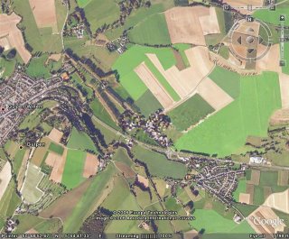
The Klooster (Monastery) in Wittem was used as a Nazi HQ during WWII
A young resident of Wittem made the discovery when he was trying to show his Father the tiny village on his computer. 'Aerosat' is the company responsible for adding the blocks to blur the visibility of the satellite imagery. Seems that there was a miscommunication between the Minstry of Defence and the company as to the goings on in Wittem. They have promised Wittem will soon be restored to the map.
In the meantime here it is in it's blurry glory....

The Klooster (Monastery) in Wittem was used as a Nazi HQ during WWII
Saturday, September 30, 2006

Subscribe to:
Comments (Atom)